
Its Springtime! And not a moment too soon after last month’s Terminalia day was a washout. If there’s a rainy day this month there’s a treat for you in this edition of the DSI Geospatial newsletter – a crossword!
Local Pubs
Publications, not hostelries, but maybe that got your attention. Let’s do a “pub” crawl of campus and see what has been brought to my attention and found with a “geospatial” search of the Uni research pages…
At the far south of campus, Dr Hamid Nasiri is a senior research associate in sustainable computing in the SCC, and has contributed to A coupled extreme gradient boosting-MPA approach for estimating daily reference evapotranspiration applied to water management in Algeria.
Heading up the spine to LEC and Sal Keith and team have had a paper out in Nature Communications on fish diversity patterns along the Great Barrier Reef. https://www.nature.com/articles/s41467-024-55128-7 – there’s data and code so this might make a great test for a reproducibility exercise. How many analyses that you did ten years ago could you do today? Sometimes I can’t do something I did ten minutes ago.
Wandering north past the delights of Alex Square to ImaginationLancaster, Paul Cureton and Elanor Brown have produced The Little Book of Digital Planning, containing basic info on this subject and a number of case studies of the use of digital technologies in the planning process, including within Lancaster.
Carrying on down the hill to the Medical School, Jessi Khaki’s PhD thesis Statistical Modelling and Mapping of Health Outcomes in Developing Countries looks at disease burdens in low- and middle-income countries and the 2030 Sustainable Development Goals.
Don’t rely on me to find your latest research for next month, do what Sal did and drop me a message!
Upcoming Events
GISRUK
The program for GISRUK 2025 has been published – there’s still time to book for this regular highlight of the UK geo-year. If you can get to the University of Bristol for April 23rd to 25th, I suggest you do so.
GISCI Map Contest
The 2025 edition of the annual GISCI Map Contest has been announced. Its open to anyone to submit creative, innovative, and informative cartography. The prize is not great, especially if you aren’t on the GISP certification track, but there’s something for everyone. Check out past winners even if you aren’t entering. Closing date April 30th.
Data Bits and Bytes
Cliopatra coming atcha!
I keep an eye out for interesting new data sets and software. This month I spotted “Cliopatria – A geospatial database of world-wide political entities from 3400BCE to 2024CE” – so if you’ve ever wanted to map the Akkadian Empire, the Kingdoms of Mercia, or the changing frontiers of modern Europe, this might be the data set for you.
Geospatial Crossword!
I love cryptic crosswords. Enough to spend too much time writing this one. Every answer has something to do with geospatial data science or geography, although this connection may be tenuous. You can also do this in an online crossword solver which will save progress, and has a print option if you want to do this on paper. No prizes, solution next month!
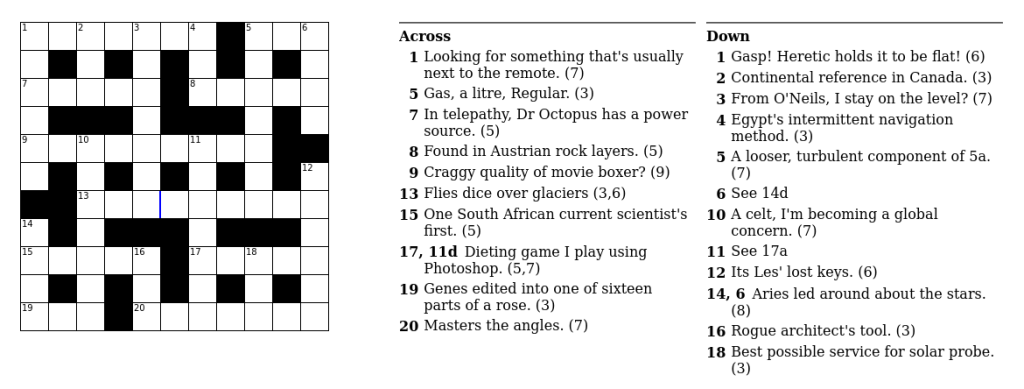
If you’ve never done a cryptic crossword before, the clues mostly have two parts – a definition of the answer, and a “construction” part describing the text in some way, although cruciverbalists often go outside these parameters. Wordplay is the name of the game.
That’s it for March. If anyone has any other spatial puzzle ideas or any other content for the April newsletter, get in touch.