
A late newsletter this month, what with some research deadlines and the whole Easter thing. I’ll probably try and do a newsletter every two months, but don’t expect absolute regularity during the holiday season.
Follow Me Follow You
Nobody watches broadcast TV these days, right? I don’t unless there’s live snooker on. So here’s a YouTube recommendation for you. GeologyHub is a one-person phenomenon of regular volcano and earthquake updates as well as in-depth analyses of geological features. Never over-sensational like many other YouTubers, he’s a full-time geologist and a clear educator. Go subscribe to his channel now.
Over on text-based social media, Jo Walsh is one of the early OpenStreetMap people, co-wrote 2005’s “Mapping Hacks – Tips and Tools for Electronic Cartography”, and is now an environmental data research engineer and and Software Sustainability Institute Fellow. Jo is sometimes around Lancaster as a member of CEH. Follow on the Fediverse for an eclectic mix of geospatial, cycling, dance, fitness and crafts centred in Glasgow.
Time Table
Conference season approaches, and the UK Open Source Geospatial group are running a FOSS4G:UK in Leeds in October. The call for papers is now open, so throw some things their way. Keep an eye on their web page (and in this newsletter) for more updates such as registration opening. I’m planning to submit a talk on one of my personal side-projects, and its explosive stuff!
Paperlate!
Have you searched the university research portal for your favourite keywords lately? Its a good way to find new and interesting things. Here’s a few recent publications found by searching for things like “map” or “geospatial”.
Three LEC researchers, Robert G. Delaney, Andrew M. Folkard & James D. Whyatt (aka Duncan, right?) together with Sudanese partners have published a paper on site assessment for dams in the Port Sudan area. With the dry April we’ve had this methodology might be worth applying to the UK.
I don’t think Engineering gets featured much in this newsletter, but two of Lancaster’s engineers, Stephen Monk and David Cheneler, have edited a special edition of Sensors on Mobile Robots: Navigation, Control and Sensing. Lots of LIDAR and fantastic trajectory-finding algorithms on very convoluted maps (p319). This is how your Amazon parcels will get to you in the future, and how the Terminator will find you (hopefully in some other timeline). Open access PDF is a click away.
Onchocerciasis – “river blindness” – is a disease that causes blindness across large parts of central Africa and elsewhere on the planet. The WHO goal of eradication means mass administration of Ivermectin across large areas. Claudio Fronterrè and partners in Cameroon and London have published an analysis of mapping the prevalence of onchocerciasis agents in Cameroon via statistical methods from survey data.
Now go search for “Pink Floyd” on the research portal and read Jenny Cubin’s PhD thesis on “Where the waves meet the sky: Virginia Woolf, Kate Bush and the expression of musical androgyny”. What’s it got to do with geospatial? Possibly nothing but why should we always stay in our lane?
The Dividing Line
Time for a mappy win. Do you think fixed area cartograms are a new invention? Maybe something Peter Snow came up with for the 2005 election? A graphic you need a computer for? Well no. On the Fediverse, SK53 recently posted these cartograms from the UK 1906 General Election – the “Liberal Landslide”. Those days, the “Liberals and Radicals” were in red, and Labour and other Socialists were yellow. Conservative and Unionists in blue.

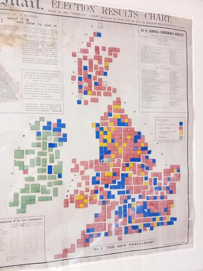
The map on the left showed the previous parliament, and readers were supplied with an initial blank map on the right with coloured paper to stick over the constituency squares as the results came in, which I imagine took a lot longer than it does these days. The text claims to be an “absolutely novel and original” idea from Lieut Colonel Sir J F G Ross of Bladensburg KCB whose other interests included fighting wars and horticulture.
Land of Confusion
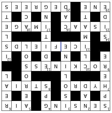
Crossword solution time! Here it is, upside down for no spoilers. You can still try solving it with no help, and now there’s also a version with buttons that will add a word if you get stuck, and another with explanations of how each clue works.
Note if anyone wants to argue that “well actually a glacier and an ice field aren’t the same thing” then please submit a fully referenced article to the International Journal of Pedantry with your case.
That’s All
No prizes for noticing the genesis of these sub-headings. Till next time, please send me anything you’d like to see here, and happy mapping.
Barry