Welcome to the first monthly DSI Geospatial Group newsmailblog! The Lancaster Data Science Institute is supporting a Geospatial Group to recognise both the importance and spread of geospatial data science across campus, and this will be a monthly round-up of mapping and spatial activity at Lancaster, with a few fun items thrown in. We have a number of researchers working with spatial data and maps over the faculties, and there should be great things to achieve by working – or just having a coffee – together.
The group is organised by myself, Barry Rowlingson, a research fellow in the Medical School, Professor Duncan Whyatt in LEC, and Professor Patricia Murrieta-Flores, of digital humanities in the History department. If anyone else is interested in helping with ideas for any geospatial data science activities, please get in touch!
This (hopefully) monthly blog post will try to be a summary of interesting things in the geospatial field that we’ve picked up over the past month or so. Contributions to the various sections are more than welcome, but anything for immediate broadcast should probably go to the DSI admin team.
Local News
Published Papers
If you have recently published or pre-printed any work with a geospatial angle let me know and I’ll list it here. Or I’ll have to search Pure and pick a few things out. Like these recent selections:
- Syndemic geographic patterns of cancer risk in a health-deprived area of England with authors from LEC, Medical School, and the local NHS.
- Investigating the spatial and temporal epidemiology of Schistosoma species infection within school-aged-children along the southern shoreline of Lake Malawi – Amber Reed’s PhD Thesis
- Towards a comprehensive river barrier mapping solution to support environmental management in Nature Water, with global partners
Opportunity Knocks
If there’s any funding calls, or PhD or jobs I’ll put them in this section. Contributions welcome.
- ExaGeo PhD Projects : These are now open for applications so point your best students at them! Deadline 17th February 2025.
Map Win/Map Fail of the Month
Win: This month’s win goes to the 2025 Geohipster Calendar, which adorns the wall you’ll see in the back of my Teams calls. You could probably still get one online and you’ll only miss January. Follow Geohipster for the call for next year’s calendar maps which goes out in October/November. I had one map of mine published in the 2021 calendar of a lockdown sideproject to map the wondrous archipelago of San Serriffe.
Fail: Volkswagen cars are reliable right? They don’t leak, right? Well, the company did. A lot of data. Tracking data they were collecting from several hundred thousand connected cars. All this found its way into mappers who produced heat maps showing where all those VWs could be found. Read all about it on the Reddit MapPorn site.
I Don’t Follow You?
In this section we’re going to suggest some people you might want to follow on social media. A lot of academic and spatial social media has now moved onto platforms such as the Fediverse (aka “Mastodon”) or BlueSky, and many people keep a more corporate front on LinkedIn. This months recommendations have a transport and movement theme:
- Anita Graser: https://mastodon.social/@underdarkGIS@fosstodon.org Anita has worked on open source tools for movement data for many years, and produces, among other things, MovingPandas, a Python library for movement data exploration and analysis, and Trajectools, a QGIS plugin for trajectory data. She is also a co-author of the book Geocomputation with Python which puts geospatial processing power into any Python programmer.
- Robin Lovelace: https://bsky.app/profile/robinlovelace.bsky.social Robin is Professor of Transport Data Science across the pennines at Leeds, and is also a co-author of the Geocomputation with Python book, which was originally Geocomputation with R and expanded into Python and Julia language forms.
Upcoming Events
This is a list of upcoming meetings and events of geospatial interest. Please send any additions to Barry for inclusion in the next month’s post.
As well as these, I’m planning a monthly coffee meeting, for anyone interested in Geospatial Data Science to meet informally over a “Mappuccino” for an hour or so. These will rotate around departments so we can see how the other departments live. Details to follow via DSI emails.
- Environmental Digital Humanities Workshop January 29th, Manchester. This event is organised by N8CIR and Manchester University’s Digital Humanities group. For more info on this and other seminars from them, check the EDH Seminars page.
- FOSS4G Europe 2025, Mostar July 14th to July 20th. This is the European gathering of the Open Source Geospatial community, with talks, workshops, coding sessions and social events.
Closing Words
That’s all for this month. Look out for the coffee break announcement, it’ll probably either be in LEC (where do you get a coffee in LEC?) or down the hill in the Medical School where we have the Hive Cafe.
Map Coda
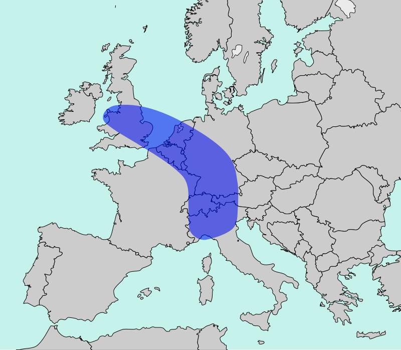
Did you know Lancaster is on the edge of the Blue Banana?